


Les Jas du Contadour

chrifor
User
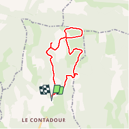

Length
14.3 km

Max alt
1427 m

Uphill gradient
379 m
Km-Effort
19.4 km

Min alt
1197 m

Downhill gradient
378 m
Boucle
Yes
Creation date :
2019-04-09 09:52:25.328
Updated on :
2019-04-09 09:52:25.38
50h00
Difficulty : Medium

FREE GPS app for hiking
 SityTrail
IGN / Geographical institutes
SityTrail Plus
The world is yours!
About
Trail Walking of 14.3 km to be discovered at Provence-Alpes-Côte d'Azur, Alpes-de-Haute-Provence, Redortiers. This trail is proposed by chrifor.
Positioning
Country:
France
Region :
Provence-Alpes-Côte d'Azur
Department/Province :
Alpes-de-Haute-Provence
Municipality :
Redortiers
Location:
Unknown
Start:(Dec)
Start:(UTM)
709998 ; 4887886 (31T) N.
Comments