


MARTEL - Lot.

AndreLACOMBE
User

Length
23 km

Max alt
311 m

Uphill gradient
607 m
Km-Effort
31 km

Min alt
106 m

Downhill gradient
576 m
Boucle
No
Creation date :
2018-06-26 13:46:34.93
Updated on :
2018-06-26 13:46:34.93
7h33
Difficulty : Medium

FREE GPS app for hiking
 SityTrail
IGN / Geographical institutes
SityTrail Plus
The world is yours!
About
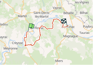
Trail Walking of 23 km to be discovered at Occitania, Lot, Montvalent. This trail is proposed by AndreLACOMBE.
Description
Départ de Pont de Gluges, puis Montvalent, Floirac et Carennac. Rañdo en ligne, prévoir voiture pour le retour.
Positioning
Country:
France
Region :
Occitania
Department/Province :
Lot
Municipality :
Montvalent
Location:
Unknown
Start:(Dec)
Start:(UTM)
391469 ; 4973575 (31T) N.
Comments