


Monts de la Madeleine 4

cron
User
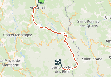

Length
20 km

Max alt
1072 m

Uphill gradient
915 m
Km-Effort
31 km

Min alt
424 m

Downhill gradient
454 m
Boucle
No
Creation date :
2018-06-26 13:47:07.07
Updated on :
2018-06-26 13:47:07.07
6h44
Difficulty : Difficult

FREE GPS app for hiking
 SityTrail
IGN / Geographical institutes
SityTrail Plus
The world is yours!
About
Trail Walking of 20 km to be discovered at Auvergne-Rhône-Alpes, Allier, Arfeuilles. This trail is proposed by cron.
Positioning
Country:
France
Region :
Auvergne-Rhône-Alpes
Department/Province :
Allier
Municipality :
Arfeuilles
Location:
Unknown
Start:(Dec)
Start:(UTM)
556090 ; 5111674 (31T) N.
Comments