


j2 aventure hautallier db

ophness
User
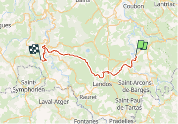

Length
40 km

Max alt
1241 m

Uphill gradient
1166 m
Km-Effort
55 km

Min alt
652 m

Downhill gradient
1055 m
Boucle
No
Creation date :
2018-06-26 14:07:05.353
Updated on :
2018-06-26 14:07:05.353
9h29
Difficulty : Unknown

FREE GPS app for hiking
 SityTrail
IGN / Geographical institutes
SityTrail Plus
The world is yours!
About
Trail Walking of 40 km to be discovered at Auvergne-Rhône-Alpes, Haute-Loire, Saint-Martin-de-Fugères. This trail is proposed by ophness.
Positioning
Country:
France
Region :
Auvergne-Rhône-Alpes
Department/Province :
Haute-Loire
Municipality :
Saint-Martin-de-Fugères
Location:
Unknown
Start:(Dec)
Start:(UTM)
572919 ; 4972055 (31T) N.
Comments