


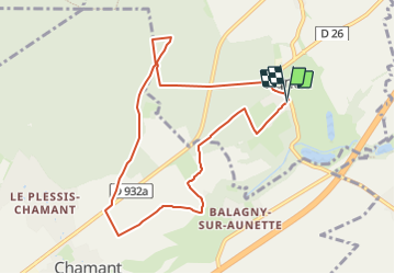
SM_OGNON-(ex BALAGNY-sur-AUNETTE)_8.3Km

GR77LP
User

Length
8.3 km

Max alt
109 m

Uphill gradient
97 m
Km-Effort
9.6 km

Min alt
69 m

Downhill gradient
95 m
Boucle
Yes
Creation date :
2019-03-04 12:58:19.201
Updated on :
2023-06-13 13:06:29.714
2h10
Difficulty : Medium

FREE GPS app for hiking
 SityTrail
IGN / Geographical institutes
SityTrail Plus
The world is yours!
About
Trail Walking of 8.3 km to be discovered at Hauts-de-France, Oise, Villers-Saint-Frambourg-Ognon. This trail is proposed by GR77LP.
Description
https://www.goelerando.fr/
DAMMARTIN en GOELE 77
Parking derrière l'église de Villers St Frambourg-Ognon
Photos
_8.3Km - Photo 1")
_8.3Km - Photo 2")
_8.3Km - Photo 3")
Positioning
Country:
France
Region :
Hauts-de-France
Department/Province :
Oise
Municipality :
Villers-Saint-Frambourg-Ognon
Location:
Unknown
Start:(Dec)
Start:(UTM)
474097 ; 5453771 (31U) N.
Comments
nc