


CLD-GM-le 15/05/2018 (St FLORET)

JackPG
User
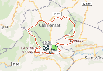

Length
9 km

Max alt
771 m

Uphill gradient
348 m
Km-Effort
13.6 km

Min alt
492 m

Downhill gradient
349 m
Boucle
Yes
Creation date :
2018-06-26 14:14:33.395
Updated on :
2018-06-26 14:14:33.395
2h54
Difficulty : Difficult

FREE GPS app for hiking
 SityTrail
IGN / Geographical institutes
SityTrail Plus
The world is yours!
About
Trail Walking of 9 km to be discovered at Auvergne-Rhône-Alpes, Puy-de-Dôme, Saint-Floret. This trail is proposed by JackPG.
Positioning
Country:
France
Region :
Auvergne-Rhône-Alpes
Department/Province :
Puy-de-Dôme
Municipality :
Saint-Floret
Location:
Unknown
Start:(Dec)
Start:(UTM)
508265 ; 5044160 (31T) N.
Comments
très belle rando.