


Barcelonne Ste Marguerite

patbt
User
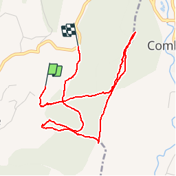

Length
5.1 km

Max alt
530 m

Uphill gradient
219 m
Km-Effort
8 km

Min alt
342 m

Downhill gradient
201 m
Boucle
No
Creation date :
2014-12-10 00:00:00.0
Updated on :
2014-12-10 00:00:00.0
2h20
Difficulty : Very easy

FREE GPS app for hiking
 SityTrail
IGN / Geographical institutes
SityTrail Plus
The world is yours!
About
Trail Walking of 5.1 km to be discovered at Auvergne-Rhône-Alpes, Drôme, Barcelonne. This trail is proposed by patbt.
Positioning
Country:
France
Region :
Auvergne-Rhône-Alpes
Department/Province :
Drôme
Municipality :
Barcelonne
Location:
Unknown
Start:(Dec)
Start:(UTM)
662753 ; 4970779 (31T) N.
Comments