


boucle - prade - concluses

mapomme
User
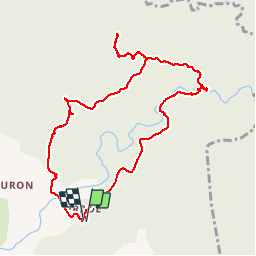

Length
10.6 km

Max alt
302 m

Uphill gradient
313 m
Km-Effort
14.8 km

Min alt
148 m

Downhill gradient
322 m
Boucle
Yes
Creation date :
2018-06-26 14:25:43.641
Updated on :
2018-06-26 14:25:43.641
4h19
Difficulty : Easy

FREE GPS app for hiking
 SityTrail
IGN / Geographical institutes
SityTrail Plus
The world is yours!
About
Trail Walking of 10.6 km to be discovered at Occitania, Gard, Lussan. This trail is proposed by mapomme.
Description
Superbe boucle - retour hasardeux sur la toute fin pendant 400 m à travers la forêt. Garder confiance .. c'est bien un chemin !
Positioning
Country:
France
Region :
Occitania
Department/Province :
Gard
Municipality :
Lussan
Location:
Unknown
Start:(Dec)
Start:(UTM)
611036 ; 4891687 (31T) N.
Comments
bonne randonnée les concluses très sympas