


20.05.2018 - Jospin et

babeth35
User

Length
21 km

Max alt
67 m

Uphill gradient
399 m
Km-Effort
26 km

Min alt
0 m

Downhill gradient
397 m
Boucle
Yes
Creation date :
2018-06-26 14:27:30.77
Updated on :
2020-07-20 15:06:14.057
5h59
Difficulty : Medium

FREE GPS app for hiking
 SityTrail
IGN / Geographical institutes
SityTrail Plus
The world is yours!
About
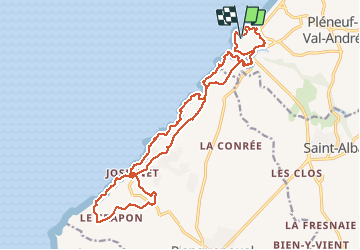
Trail Walking of 21 km to be discovered at Brittany, Côtes-d'Armor, Pléneuf-Val-André. This trail is proposed by babeth35.
Positioning
Country:
France
Region :
Brittany
Department/Province :
Côtes-d'Armor
Municipality :
Pléneuf-Val-André
Location:
Unknown
Start:(Dec)
Start:(UTM)
531915 ; 5381076 (30U) N.
Comments