Droue sur Drouette st hillarion

topophil
User
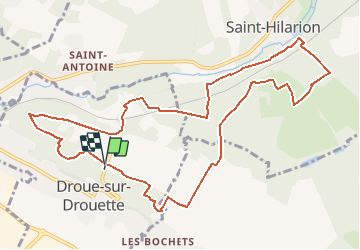

Length
11.6 km

Max alt
177 m

Uphill gradient
164 m
Km-Effort
13.8 km

Min alt
125 m

Downhill gradient
165 m
Boucle
Yes
Creation date :
2018-06-26 14:32:49.3
Updated on :
2018-06-26 14:32:49.3
3h00
Difficulty : Unknown

FREE GPS app for hiking
 SityTrail
IGN / Geographical institutes
SityTrail Plus
The world is yours!
About
Trail Walking of 11.6 km to be discovered at Centre-Loire Valley, Eure-et-Loir, Droue-sur-Drouette. This trail is proposed by topophil.
Description
11km5
Positioning
Country:
France
Region :
Centre-Loire Valley
Department/Province :
Eure-et-Loir
Municipality :
Droue-sur-Drouette
Location:
Unknown
Start:(Dec)
Start:(UTM)
404480 ; 5384226 (31U) N.
Comments