


Arboras

ARVIEU
User
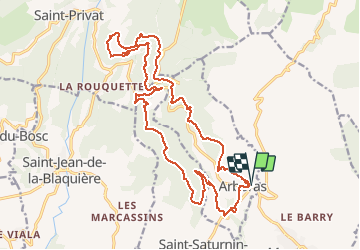

Length
23 km

Max alt
677 m

Uphill gradient
713 m
Km-Effort
33 km

Min alt
160 m

Downhill gradient
718 m
Boucle
Yes
Creation date :
2018-06-26 14:38:47.802
Updated on :
2018-06-26 14:38:47.802
6h00
Difficulty : Medium

FREE GPS app for hiking
 SityTrail
IGN / Geographical institutes
SityTrail Plus
The world is yours!
About
Trail Walking of 23 km to be discovered at Occitania, Hérault, Arboras. This trail is proposed by ARVIEU.
Description
Le dénivelé est pratiquement absorbé le matin (467 m). Le sol ne présente aucune difficulté, peu de pierres. La marche est rapide.
Positioning
Country:
France
Region :
Occitania
Department/Province :
Hérault
Municipality :
Arboras
Location:
Unknown
Start:(Dec)
Start:(UTM)
539369 ; 4839919 (31T) N.
Comments
Pas de difficultés majeures si ce n'est la distance