


Vendange 2018 21 KM

JackPG
User
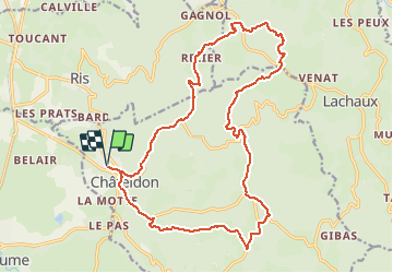

Length
21 km

Max alt
638 m

Uphill gradient
659 m
Km-Effort
30 km

Min alt
304 m

Downhill gradient
659 m
Boucle
Yes
Creation date :
2018-06-26 14:44:16.798
Updated on :
2018-06-26 14:44:16.798
6h17
Difficulty : Difficult

FREE GPS app for hiking
 SityTrail
IGN / Geographical institutes
SityTrail Plus
The world is yours!
About
Trail Walking of 21 km to be discovered at Auvergne-Rhône-Alpes, Puy-de-Dôme, Châteldon. This trail is proposed by JackPG.
Positioning
Country:
France
Region :
Auvergne-Rhône-Alpes
Department/Province :
Puy-de-Dôme
Municipality :
Châteldon
Location:
Unknown
Start:(Dec)
Start:(UTM)
539918 ; 5092003 (31T) N.
Comments