


CÉZAS 20 KM

ARVIEU
User
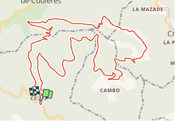

Length
18.2 km

Max alt
877 m

Uphill gradient
681 m
Km-Effort
27 km

Min alt
530 m

Downhill gradient
671 m
Boucle
Yes
Creation date :
2018-06-26 14:44:49.43
Updated on :
2018-06-26 14:44:49.43
5h30
Difficulty : Medium

FREE GPS app for hiking
 SityTrail
IGN / Geographical institutes
SityTrail Plus
The world is yours!
About
Trail Walking of 18.2 km to be discovered at Occitania, Gard, Sumène. This trail is proposed by ARVIEU.
Description
Rando essentiellement sur chemin DFCI avant un bon dénivelé entre les km 12 et 15.
Positioning
Country:
France
Region :
Occitania
Department/Province :
Gard
Municipality :
Sumène
Location:
Unknown
Start:(Dec)
Start:(UTM)
562457 ; 4869408 (31T) N.
Comments