


ski metabief

i20
User
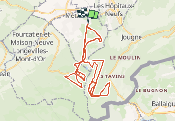

Length
35 km

Max alt
1417 m

Uphill gradient
2878 m
Km-Effort
73 km

Min alt
885 m

Downhill gradient
2884 m
Boucle
Yes
Creation date :
2014-12-10 00:00:00.0
Updated on :
2014-12-10 00:00:00.0
5h09
Difficulty : Unknown

FREE GPS app for hiking
 SityTrail
IGN / Geographical institutes
SityTrail Plus
The world is yours!
About
Trail Other activity of 35 km to be discovered at Bourgogne-Franche-Comté, Doubs, Métabief. This trail is proposed by i20.
Positioning
Country:
France
Region :
Bourgogne-Franche-Comté
Department/Province :
Doubs
Municipality :
Métabief
Location:
Unknown
Start:(Dec)
Start:(UTM)
298183 ; 5182821 (32T) N.
Comments