


Montdardier-cirque de Navacelle

bernir
User
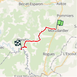

Length
13.6 km

Max alt
671 m

Uphill gradient
233 m
Km-Effort
17.6 km

Min alt
337 m

Downhill gradient
496 m
Boucle
No
Creation date :
2018-06-26 15:01:48.678
Updated on :
2018-06-26 15:01:48.678
3h36
Difficulty : Medium

FREE GPS app for hiking
 SityTrail
IGN / Geographical institutes
SityTrail Plus
The world is yours!
About
Trail Walking of 13.6 km to be discovered at Occitania, Gard, Montdardier. This trail is proposed by bernir.
Positioning
Country:
France
Region :
Occitania
Department/Province :
Gard
Municipality :
Montdardier
Location:
Unknown
Start:(Dec)
Start:(UTM)
547216 ; 4864095 (31T) N.
Comments