


2018-05-23 Rando CVA Meyrueis vers Nivoliers Reel

holtzv
User GUIDE
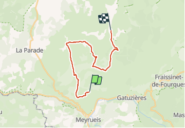

Length
21 km

Max alt
1078 m

Uphill gradient
450 m
Km-Effort
27 km

Min alt
933 m

Downhill gradient
448 m
Boucle
No
Creation date :
2018-06-26 15:05:18.041
Updated on :
2018-06-26 15:05:18.041
3h22
Difficulty : Unknown

FREE GPS app for hiking
 SityTrail
IGN / Geographical institutes
SityTrail Plus
The world is yours!
About
Trail Equestrian of 21 km to be discovered at Occitania, Lozère, Meyrueis. This trail is proposed by holtzv.

Positioning
Country:
France
Region :
Occitania
Department/Province :
Lozère
Municipality :
Meyrueis
Location:
Unknown
Start:(Dec)
Start:(UTM)
534522 ; 4894718 (31T) N.
Comments