


Dérailleurs 3 juin 18 AH

LEROYFR
User
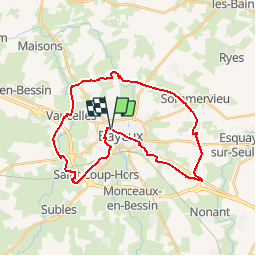

Length
28 km

Max alt
72 m

Uphill gradient
195 m
Km-Effort
30 km

Min alt
25 m

Downhill gradient
195 m
Boucle
Yes
Creation date :
2018-06-26 15:08:28.458
Updated on :
2018-06-26 15:08:28.458
1h46
Difficulty : Easy

FREE GPS app for hiking
 SityTrail
IGN / Geographical institutes
SityTrail Plus
The world is yours!
About
Trail Cycle of 28 km to be discovered at Normandy, Calvados, Bayeux. This trail is proposed by LEROYFR.
Description
Pause café à mi route Vaux sur aure
Positioning
Country:
France
Region :
Normandy
Department/Province :
Calvados
Municipality :
Bayeux
Location:
Unknown
Start:(Dec)
Start:(UTM)
666659 ; 5461046 (30U) N.
Comments