


Ténérife volcan Chinyero

cron
User
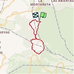

Length
12 km

Max alt
1540 m

Uphill gradient
342 m
Km-Effort
16.5 km

Min alt
1227 m

Downhill gradient
346 m
Boucle
Yes
Creation date :
2018-06-27 12:04:24.685
Updated on :
2018-06-27 12:04:24.685
3h32
Difficulty : Medium

FREE GPS app for hiking
 SityTrail
IGN / Geographical institutes
SityTrail Plus
The world is yours!
About
Trail Walking of 12 km to be discovered at Canary Islands, Santa Cruz de Tenerife, Garachico. This trail is proposed by cron.
Positioning
Country:
Spain
Region :
Canary Islands
Department/Province :
Santa Cruz de Tenerife
Municipality :
Garachico
Location:
Unknown
Start:(Dec)
Start:(UTM)
327702 ; 3133866 (28R) N.
Comments