


chateau A / M

daniel77
User
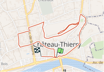

Length
3.1 km

Max alt
103 m

Uphill gradient
45 m
Km-Effort
3.7 km

Min alt
60 m

Downhill gradient
48 m
Boucle
Yes
Creation date :
2018-06-26 15:14:59.114
Updated on :
2018-06-26 15:14:59.114
50m
Difficulty : Medium

FREE GPS app for hiking
 SityTrail
IGN / Geographical institutes
SityTrail Plus
The world is yours!
About
Trail Walking of 3.1 km to be discovered at Hauts-de-France, Aisne, Château-Thierry. This trail is proposed by daniel77.
Positioning
Country:
France
Region :
Hauts-de-France
Department/Province :
Aisne
Municipality :
Château-Thierry
Location:
Unknown
Start:(Dec)
Start:(UTM)
529422 ; 5432478 (31U) N.
Comments