


via rhona j4

ericf64
User

Length
60 km

Max alt
96 m

Uphill gradient
437 m
Km-Effort
66 km

Min alt
43 m

Downhill gradient
471 m
Boucle
No
Creation date :
2018-06-26 15:15:48.97
Updated on :
2019-08-30 10:12:42.758
--
Difficulty : Easy

FREE GPS app for hiking
 SityTrail
IGN / Geographical institutes
SityTrail Plus
The world is yours!
About
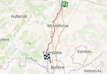
Trail Bicycle tourism of 60 km to be discovered at Auvergne-Rhône-Alpes, Ardèche, Cruas. This trail is proposed by ericf64.
Description
cruas lapalud
Positioning
Country:
France
Region :
Auvergne-Rhône-Alpes
Department/Province :
Ardèche
Municipality :
Cruas
Location:
Unknown
Start:(Dec)
Start:(UTM)
640878 ; 4946440 (31T) N.
Comments