


via rhona j7

ericf64
User

Length
48 km

Max alt
19 m

Uphill gradient
146 m
Km-Effort
50 km

Min alt
-3 m

Downhill gradient
161 m
Boucle
No
Creation date :
2018-06-26 15:15:51.683
Updated on :
2019-08-30 10:13:24.796
--
Difficulty : Easy

FREE GPS app for hiking
 SityTrail
IGN / Geographical institutes
SityTrail Plus
The world is yours!
About
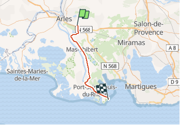
Trail Bicycle tourism of 48 km to be discovered at Provence-Alpes-Côte d'Azur, Bouches-du-Rhône, Arles. This trail is proposed by ericf64.
Description
Arles plage Napoléon
Positioning
Country:
France
Region :
Provence-Alpes-Côte d'Azur
Department/Province :
Bouches-du-Rhône
Municipality :
Arles
Location:
Unknown
Start:(Dec)
Start:(UTM)
637555 ; 4834358 (31T) N.
Comments