


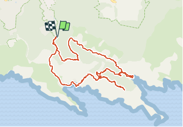
MARSEILLE - Les Baumettes.

AndreLACOMBE
User

Length
12.1 km

Max alt
231 m

Uphill gradient
527 m
Km-Effort
19.2 km

Min alt
4 m

Downhill gradient
528 m
Boucle
Yes
Creation date :
2018-06-26 15:18:21.368
Updated on :
2018-06-26 15:18:21.368
6h46
Difficulty : Medium

FREE GPS app for hiking
 SityTrail
IGN / Geographical institutes
SityTrail Plus
The world is yours!
About
Trail Walking of 12.1 km to be discovered at Provence-Alpes-Côte d'Azur, Bouches-du-Rhône, Marseille. This trail is proposed by AndreLACOMBE.
Description
Départ parking chemin de Morgiou. Col de Morgiou, calanque de Morgiou, le "Carrefour", crête de Morgiou (partiel), calanque de Sormiou et retour.
Photos

Positioning
Country:
France
Region :
Provence-Alpes-Côte d'Azur
Department/Province :
Bouches-du-Rhône
Municipality :
Marseille
Location:
9th Arrondissement
Start:(Dec)
Start:(UTM)
696380 ; 4788380 (31T) N.
Comments