


HorseshoeBend

raymondfn
User
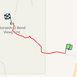

Length
950 m

Max alt
1331 m

Uphill gradient
11 m
Km-Effort
1.2 km

Min alt
1287 m

Downhill gradient
42 m
Boucle
No
Creation date :
2018-06-26 15:23:12.927
Updated on :
2018-06-26 15:23:12.927
17m
Difficulty : Medium

FREE GPS app for hiking
 SityTrail
IGN / Geographical institutes
SityTrail Plus
The world is yours!
About
Trail Walking of 950 m to be discovered at Arizona, Coconino County, Unknown. This trail is proposed by raymondfn.
Positioning
Country:
United States
Region :
Arizona
Department/Province :
Coconino County
Municipality :
Unknown
Location:
Page
Start:(Dec)
Start:(UTM)
455170 ; 4081310 (12S) N.
Comments