


reculée de beaume

choubaka77
User
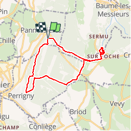

Length
14.1 km

Max alt
569 m

Uphill gradient
443 m
Km-Effort
20 km

Min alt
366 m

Downhill gradient
440 m
Boucle
Yes
Creation date :
2018-06-26 15:26:16.303
Updated on :
2018-06-26 15:26:16.303
3h00
Difficulty : Medium

FREE GPS app for hiking
 SityTrail
IGN / Geographical institutes
SityTrail Plus
The world is yours!
About
Trail Running of 14.1 km to be discovered at Bourgogne-Franche-Comté, Jura, Pannessières. This trail is proposed by choubaka77.
Positioning
Country:
France
Region :
Bourgogne-Franche-Comté
Department/Province :
Jura
Municipality :
Pannessières
Location:
Unknown
Start:(Dec)
Start:(UTM)
699003 ; 5174590 (31T) N.
Comments