


Les 2 Windstein

Claudele
User
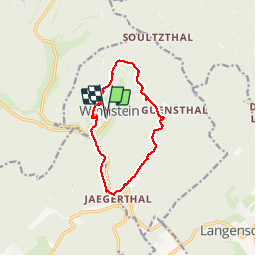

Length
12.2 km

Max alt
436 m

Uphill gradient
424 m
Km-Effort
17.9 km

Min alt
200 m

Downhill gradient
422 m
Boucle
Yes
Creation date :
2018-06-26 15:33:22.097
Updated on :
2018-06-26 15:33:22.097
5h35
Difficulty : Easy

FREE GPS app for hiking
 SityTrail
IGN / Geographical institutes
SityTrail Plus
The world is yours!
About
Trail Walking of 12.2 km to be discovered at Grand Est, Bas-Rhin, Windstein. This trail is proposed by Claudele.
Positioning
Country:
France
Region :
Grand Est
Department/Province :
Bas-Rhin
Municipality :
Windstein
Location:
Unknown
Start:(Dec)
Start:(UTM)
403643 ; 5427548 (32U) N.
Comments