


Le poirier

pampalala
User
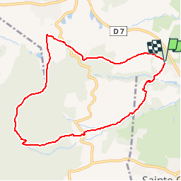

Length
8.8 km

Max alt
601 m

Uphill gradient
305 m
Km-Effort
12.8 km

Min alt
327 m

Downhill gradient
305 m
Boucle
Yes
Creation date :
2014-12-10 00:00:00.0
Updated on :
2014-12-10 00:00:00.0
--
Difficulty : Unknown

FREE GPS app for hiking
 SityTrail
IGN / Geographical institutes
SityTrail Plus
The world is yours!
About
Trail Other activity of 8.8 km to be discovered at Auvergne-Rhône-Alpes, Rhône, Lentilly. This trail is proposed by pampalala.
Positioning
Country:
France
Region :
Auvergne-Rhône-Alpes
Department/Province :
Rhône
Municipality :
Lentilly
Location:
Unknown
Start:(Dec)
Start:(UTM)
631061 ; 5072702 (31T) N.
Comments