


chirouble 07-06-18

Thomasdanielle
User
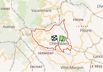

Length
14.4 km

Max alt
690 m

Uphill gradient
558 m
Km-Effort
22 km

Min alt
286 m

Downhill gradient
557 m
Boucle
Yes
Creation date :
2018-06-26 15:49:11.206
Updated on :
2023-03-07 15:04:11.224
5h19
Difficulty : Unknown

FREE GPS app for hiking
 SityTrail
IGN / Geographical institutes
SityTrail Plus
The world is yours!
About
Trail Walking of 14.4 km to be discovered at Auvergne-Rhône-Alpes, Rhône, Chiroubles. This trail is proposed by Thomasdanielle.
Description
Trop de goudron
Positioning
Country:
France
Region :
Auvergne-Rhône-Alpes
Department/Province :
Rhône
Municipality :
Chiroubles
Location:
Unknown
Start:(Dec)
Start:(UTM)
628525 ; 5115385 (31T) N.
Comments