


Meulière des Dauphins

gallo
User
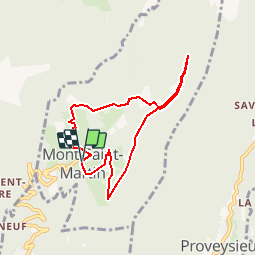

Length
7.1 km

Max alt
1081 m

Uphill gradient
390 m
Km-Effort
12.4 km

Min alt
741 m

Downhill gradient
391 m
Boucle
Yes
Creation date :
2018-06-26 16:05:24.442
Updated on :
2018-06-26 16:05:24.442
2h31
Difficulty : Easy

FREE GPS app for hiking
 SityTrail
IGN / Geographical institutes
SityTrail Plus
The world is yours!
About
Trail Walking of 7.1 km to be discovered at Auvergne-Rhône-Alpes, Isère, Mont-Saint-Martin. This trail is proposed by gallo.
Positioning
Country:
France
Region :
Auvergne-Rhône-Alpes
Department/Province :
Isère
Municipality :
Mont-Saint-Martin
Location:
Unknown
Start:(Dec)
Start:(UTM)
709783 ; 5016596 (31T) N.
Comments