


du manoir de Trouzilit au Port Aber Wrach't

phimar_2612
User
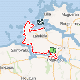

Length
23 km

Max alt
41 m

Uphill gradient
265 m
Km-Effort
27 km

Min alt
-3 m

Downhill gradient
300 m
Boucle
No
Creation date :
2018-06-26 16:12:16.974
Updated on :
2018-06-26 16:12:16.974
5h40
Difficulty : Medium

FREE GPS app for hiking
 SityTrail
IGN / Geographical institutes
SityTrail Plus
The world is yours!
About
Trail Walking of 23 km to be discovered at Brittany, Finistère, Tréglonou. This trail is proposed by phimar_2612.
Positioning
Country:
France
Region :
Brittany
Department/Province :
Finistère
Municipality :
Tréglonou
Location:
Unknown
Start:(Dec)
Start:(UTM)
385376 ; 5379236 (30U) N.
Comments