


St Jean cap ferrat

aljac
User
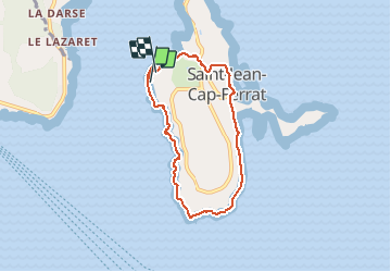

Length
6.5 km

Max alt
49 m

Uphill gradient
155 m
Km-Effort
8.5 km

Min alt
-1 m

Downhill gradient
150 m
Boucle
Yes
Creation date :
2018-06-26 16:17:00.216
Updated on :
2018-06-26 16:17:00.216
2h30
Difficulty : Unknown

FREE GPS app for hiking
 SityTrail
IGN / Geographical institutes
SityTrail Plus
The world is yours!
About
Trail Other activity of 6.5 km to be discovered at Provence-Alpes-Côte d'Azur, Maritime Alps, Saint-Jean-Cap-Ferrat. This trail is proposed by aljac.
Positioning
Country:
France
Region :
Provence-Alpes-Côte d'Azur
Department/Province :
Maritime Alps
Municipality :
Saint-Jean-Cap-Ferrat
Location:
Unknown
Start:(Dec)
Start:(UTM)
364663 ; 4838827 (32T) N.
Comments