


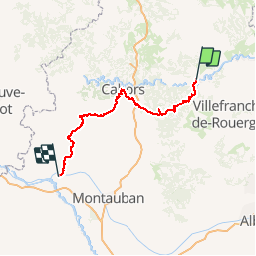
Compostelle 2013 - Cajarc -> Moissac

uru2010
User

Length
154 km

Max alt
374 m

Uphill gradient
2870 m
Km-Effort
193 km

Min alt
73 m

Downhill gradient
2943 m
Boucle
No
Creation date :
2018-06-26 16:22:38.118
Updated on :
2018-06-26 16:22:38.118
39h15
Difficulty : Very easy

FREE GPS app for hiking
 SityTrail
IGN / Geographical institutes
SityTrail Plus
The world is yours!
About
Trail Walking of 154 km to be discovered at Occitania, Lot, Cajarc. This trail is proposed by uru2010.
Description
Chemin de Compostelle en 2013 :
Cajarc -> Moissac
Positioning
Country:
France
Region :
Occitania
Department/Province :
Lot
Municipality :
Cajarc
Location:
Unknown
Start:(Dec)
Start:(UTM)
407684 ; 4926503 (31T) N.
Comments