


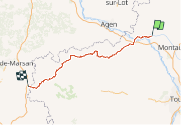
Compostelle 2014 - Moissac -> Aire-sur-l'Adour

uru2010
User

Length
174 km

Max alt
219 m

Uphill gradient
2969 m
Km-Effort
214 km

Min alt
55 m

Downhill gradient
2963 m
Boucle
No
Creation date :
2018-06-26 16:22:44.311
Updated on :
2018-06-26 16:22:44.311
43h30
Difficulty : Medium

FREE GPS app for hiking
 SityTrail
IGN / Geographical institutes
SityTrail Plus
The world is yours!
About
Trail Walking of 174 km to be discovered at Occitania, Tarn-et-Garonne, Moissac. This trail is proposed by uru2010.
Description
Chemin de St Jacques de Compostelle en 2014 :
Moissac -> Aire-sur-l'Adour
Positioning
Country:
France
Region :
Occitania
Department/Province :
Tarn-et-Garonne
Municipality :
Moissac
Location:
Unknown
Start:(Dec)
Start:(UTM)
346795 ; 4885124 (31T) N.
Comments