


Boult

i20
User

Length
14.1 km

Max alt
353 m

Uphill gradient
261 m
Km-Effort
17.6 km

Min alt
232 m

Downhill gradient
262 m
Boucle
Yes
Creation date :
2018-06-26 16:32:12.389
Updated on :
2018-06-26 16:32:12.389
3h12
Difficulty : Medium

FREE GPS app for hiking
 SityTrail
IGN / Geographical institutes
SityTrail Plus
The world is yours!
About
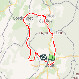
Trail Walking of 14.1 km to be discovered at Bourgogne-Franche-Comté, Haute-Saône, Boult. This trail is proposed by i20.
Positioning
Country:
France
Region :
Bourgogne-Franche-Comté
Department/Province :
Haute-Saône
Municipality :
Boult
Location:
Unknown
Start:(Dec)
Start:(UTM)
726320 ; 5252001 (31T) N.
Comments