


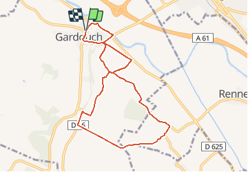
Gardouch fait

pidjam
User

Length
9 km

Max alt
255 m

Uphill gradient
142 m
Km-Effort
10.9 km

Min alt
176 m

Downhill gradient
143 m
Boucle
Yes
Creation date :
2018-06-26 16:52:54.896
Updated on :
2018-06-26 16:52:54.896
2h04
Difficulty : Easy

FREE GPS app for hiking
 SityTrail
IGN / Geographical institutes
SityTrail Plus
The world is yours!
About
Trail Walking of 9 km to be discovered at Occitania, Haute-Garonne, Gardouch. This trail is proposed by pidjam.
Positioning
Country:
France
Region :
Occitania
Department/Province :
Haute-Garonne
Municipality :
Gardouch
Location:
Unknown
Start:(Dec)
Start:(UTM)
393488 ; 4805264 (31T) N.
Comments