


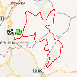
Balaruc - Sud Gardiole

grageot
User

Length
11.8 km

Max alt
165 m

Uphill gradient
282 m
Km-Effort
15.5 km

Min alt
18 m

Downhill gradient
282 m
Boucle
Yes
Creation date :
2018-06-26 16:54:30.401
Updated on :
2018-06-26 16:54:30.401
3h55
Difficulty : Easy

FREE GPS app for hiking
 SityTrail
IGN / Geographical institutes
SityTrail Plus
The world is yours!
About
Trail Walking of 11.8 km to be discovered at Occitania, Hérault, Balaruc-le-Vieux. This trail is proposed by grageot.
Description
juin 2018 randonnée facile mais il y a beaucoup de chemins non tracès sur la carte. De jolies vue sur ète et l'étang de Thau
Positioning
Country:
France
Region :
Occitania
Department/Province :
Hérault
Municipality :
Balaruc-le-Vieux
Location:
Unknown
Start:(Dec)
Start:(UTM)
556127 ; 4812348 (31T) N.
Comments