


Cipieres Plateau boucle

elcanario
User
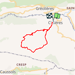

Length
12.7 km

Max alt
1249 m

Uphill gradient
532 m
Km-Effort
19.8 km

Min alt
765 m

Downhill gradient
535 m
Boucle
Yes
Creation date :
2018-06-26 17:09:25.179
Updated on :
2018-06-26 17:09:25.179
4h52
Difficulty : Easy

FREE GPS app for hiking
 SityTrail
IGN / Geographical institutes
SityTrail Plus
The world is yours!
About
Trail Walking of 12.7 km to be discovered at Provence-Alpes-Côte d'Azur, Maritime Alps, Cipières. This trail is proposed by elcanario.
Positioning
Country:
France
Region :
Provence-Alpes-Côte d'Azur
Department/Province :
Maritime Alps
Municipality :
Cipières
Location:
Unknown
Start:(Dec)
Start:(UTM)
335324 ; 4849837 (32T) N.
Comments