


rochegude

mapomme
User
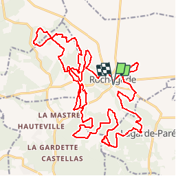

Length
35 km

Max alt
278 m

Uphill gradient
683 m
Km-Effort
44 km

Min alt
90 m

Downhill gradient
683 m
Boucle
Yes
Creation date :
2014-12-10 00:00:00.0
Updated on :
2014-12-10 00:00:00.0
--
Difficulty : Unknown

FREE GPS app for hiking
 SityTrail
IGN / Geographical institutes
SityTrail Plus
The world is yours!
About
Trail Mountain bike of 35 km to be discovered at Auvergne-Rhône-Alpes, Drôme, Rochegude. This trail is proposed by mapomme.
Description
a tester ... pour import iphone
Positioning
Country:
France
Region :
Auvergne-Rhône-Alpes
Department/Province :
Drôme
Municipality :
Rochegude
Location:
Unknown
Start:(Dec)
Start:(UTM)
646106 ; 4900889 (31T) N.
Comments