


Andorre 6

murph
User
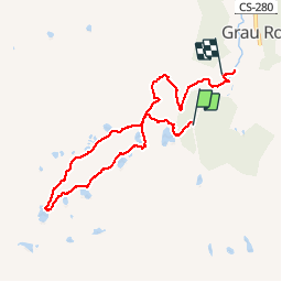

Length
8.1 km

Max alt
2517 m

Uphill gradient
324 m
Km-Effort
12.8 km

Min alt
2099 m

Downhill gradient
432 m
Boucle
No
Creation date :
2019-01-15 12:21:29.304
Updated on :
2019-12-22 15:18:18.373
5h55
Difficulty : Unknown

FREE GPS app for hiking
 SityTrail
IGN / Geographical institutes
SityTrail Plus
The world is yours!
About
Trail Other activity of 8.1 km to be discovered at Andorra. This trail is proposed by murph.
Positioning
Country:
Andorra
Region :
Unknown
Department/Province :
Unknown
Municipality :
Unknown
Location:
Unknown
Start:(Dec)
Start:(UTM)
392525 ; 4709030 (31T) N.
Comments