


Andorre 3

murph
User
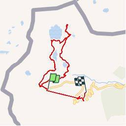

Length
8.2 km

Max alt
2433 m

Uphill gradient
434 m
Km-Effort
14.6 km

Min alt
2031 m

Downhill gradient
615 m
Boucle
No
Creation date :
2019-01-15 12:21:35.409
Updated on :
2019-12-22 15:18:09.354
5h22
Difficulty : Unknown

FREE GPS app for hiking
 SityTrail
IGN / Geographical institutes
SityTrail Plus
The world is yours!
About
Trail Other activity of 8.2 km to be discovered at Andorra. This trail is proposed by murph.
Positioning
Country:
Andorra
Region :
Andorre-la-Vieille
Department/Province :
Ordino
Municipality :
el Serrat
Location:
Unknown
Start:(Dec)
Start:(UTM)
375698 ; 4720954 (31T) N.
Comments