


ferisson

barney06
User
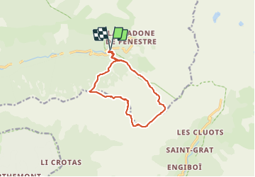

Length
12.6 km

Max alt
2489 m

Uphill gradient
856 m
Km-Effort
24 km

Min alt
1699 m

Downhill gradient
857 m
Boucle
Yes
Creation date :
2019-01-15 12:26:40.601
Updated on :
2019-01-15 12:26:40.601
8h03
Difficulty : Medium

FREE GPS app for hiking
 SityTrail
IGN / Geographical institutes
SityTrail Plus
The world is yours!
About
Trail Walking of 12.6 km to be discovered at Provence-Alpes-Côte d'Azur, Maritime Alps, Saint-Martin-Vésubie. This trail is proposed by barney06.
Description
rando
Positioning
Country:
France
Region :
Provence-Alpes-Côte d'Azur
Department/Province :
Maritime Alps
Municipality :
Saint-Martin-Vésubie
Location:
Unknown
Start:(Dec)
Start:(UTM)
367644 ; 4883319 (32T) N.
Comments