


Valgaudemar - La Chapelle Les Oulles du Diable - 1.4km 20m 25mn - 2018 07 05 - public

Orcal37
User GUIDE
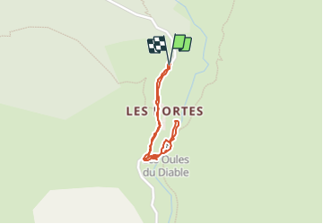

Length
1.4 km

Max alt
1277 m

Uphill gradient
21 m
Km-Effort
1.7 km

Min alt
1253 m

Downhill gradient
22 m
Boucle
Yes
Creation date :
2019-01-15 12:34:02.769
Updated on :
2021-09-09 16:24:52.007
35m
Difficulty : Very easy

FREE GPS app for hiking
 SityTrail
IGN / Geographical institutes
SityTrail Plus
The world is yours!
About
Trail Walking of 1.4 km to be discovered at Provence-Alpes-Côte d'Azur, Hautes-Alpes, La Chapelle-en-Valgaudémar. This trail is proposed by Orcal37.
Description
Valgaudemar - La Chapelle Les Oulles du Diable - 1.4km 20m 25mn - 2018 07 05 - public
Photos


Positioning
Country:
France
Region :
Provence-Alpes-Côte d'Azur
Department/Province :
Hautes-Alpes
Municipality :
La Chapelle-en-Valgaudémar
Location:
Unknown
Start:(Dec)
Start:(UTM)
278293 ; 4965870 (32T) N.
Comments