Trail Walking Villon - villon 2 - Photo
 genndor
genndor

User

© OpenStreetMap contributors
Length
Length
19.4 km
Max alt
Max alt
336 m
Uphill gradient
Uphill gradient
382 m
Km-Effort
Km-Effort  
24 km
Min alt
Min alt
191 m
Downhill gradient
Downhill gradient
382 m
Boucle
Boucle
Yes
Creation date :
2019-01-15 12:38:19.737
Updated on :
2019-01-15 12:38:19.737

(1 Reviews)

Walking
Walking
5h16
Difficulty : Medium

Scan this QR Code to open this trail in the SityTrail application

FREE GPS app for hiking

Logo SityTrail SityTrail

IGN / Geographical institutes

Download SityTrail from the App Store Download SityTrail from Google Play

Logo SityTrail SityTrail World

The world is yours!

Download SityTrail from the App Store Download SityTrail from Google Play Download SityTrail on Huawei AppGallery

About

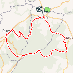
Trail Walking of 19.4 km to be discovered at Bourgogne-Franche-Comté, Yonne, Villon. This trail is proposed by genndor.

Elevation profile

Positioning

Country:
France
Region :
Bourgogne-Franche-Comté
Department/Province :
Yonne
Municipality :
Villon
Location:
Unknown
Start:(UTM)
588860 ; 5307073 (31T) N.

Comments

Please log in to post a review or rate the element


Attention certains Chemins n’existent plus donc en orientation GPS


Trails nearby

Trail Walking Thorey - rando Thorey - Photo
Walking
richardetchantal

Walking

Very easy
Thorey, Bourgogne-Franche-Comté, Yonne, France
12.7 km | 16.4 km-effort
3h 1min
Yes
Trail Walking Étourvy - etourvy - Photo
Walking
randoam

Walking

Very easy
Étourvy, Grand Est, Aube, France
23 km | 29 km-effort
7h 7min
Yes
Trail Walking Cruzy-le-Châtel - 3 château 2016 - Photo
Walking
theo89

Walking

Very easy
Cruzy-le-Châtel, Bourgogne-Franche-Comté, Yonne, France
19.8 km | 24 km-effort
4h 8min
No


Close
My subscriptions