


2018-07-08 Marche Ville

holtzv
User GUIDE
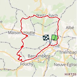

Length
16.4 km

Max alt
593 m

Uphill gradient
711 m
Km-Effort
26 km

Min alt
264 m

Downhill gradient
717 m
Boucle
Yes
Creation date :
2019-01-15 12:38:37.696
Updated on :
2019-01-15 12:38:37.696
5h19
Difficulty : Unknown

FREE GPS app for hiking
 SityTrail
IGN / Geographical institutes
SityTrail Plus
The world is yours!
About
Trail Walking of 16.4 km to be discovered at Grand Est, Bas-Rhin, Villé. This trail is proposed by holtzv.
Positioning
Country:
France
Region :
Grand Est
Department/Province :
Bas-Rhin
Municipality :
Villé
Location:
Unknown
Start:(Dec)
Start:(UTM)
373810 ; 5355886 (32U) N.
Comments