Excursión Carrera Sainte-Austreberthe - Hivernale du Raid Normand - Photo
 hgoye
hgoye

Usuario

© OpenStreetMap contributors
Longitud
Longitud
48 km
Altitud máxima
Altitud máxima
154 m
Desnivel positivo
Desnivel positivo
933 m
Km-Effort
Km-Effort  
61 km
Altitud mínima
Altitud mínima
2 m
Desnivel negativo
Desnivel negativo
1049 m
Boucle
Boucle
No
Fecha de creación :
2014-12-10 00:00:00.0
Última modificación :
2014-12-10 00:00:00.0

(0 Opinión)

Carrera
Carrera
10h29
Dificultad : Muy difícil

Escanee este código QR para abrir la excursión en la aplicación SityTrail

Aplicación GPS de excursión GRATIS

Logo SityTrail SityTrail

IGN / Institutos geográficos

Descargar SityTrail en App Store Descargar SityTrail en Google Play

Logo SityTrail SityTrail World

El mundo es suyo

Descargar SityTrail en App Store Descargar SityTrail en Google Play Descargar SityTrail en Huawei AppGallery

A propósito

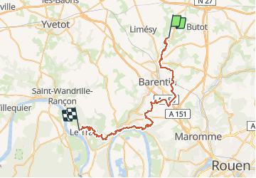
Ruta Carrera de 48 km a descubrir en Normandía, Sena-Marítimo, Sainte-Austreberthe. Esta ruta ha sido propuesta por hgoye.

Descripción

Parcours de l'hivernale du RAID Normand 2012. Parcours 42 kilomètres (à la base) qui en fait pas loin de 49 en définitive.

Perfil altimétrico

Puntos de interés

Punto de interés Sainte-Austreberthe - CP 1 - Photo
hgoye
SAINTE-AUSTREBERTHE 
Punto de interés Sainte-Austreberthe - CP2 - Photo
hgoye
SAINTE-AUSTREBERTHE 
Punto de interés Goupillières - CP 3 - Photo
hgoye
GOUPILLIÈRES 
Punto de interés Pavilly - CP 4 - Photo
hgoye
PAVILLY 
Punto de interés Pavilly - CP 5 - Photo
hgoye
PAVILLY 
Punto de interés Pavilly - CP 6 - Photo
hgoye
PAVILLY 
Punto de interés Pavilly - CP 7 - Photo
hgoye
PAVILLY 
Punto de interés Pavilly - CP 8 - Photo
hgoye
PAVILLY 
Punto de interés Fresquiennes - CP 9 - Photo
hgoye
FRESQUIENNES 
Punto de interés Fresquiennes - CP 14 - Photo
hgoye
FRESQUIENNES 
Punto de interés Pissy-Pôville - CP 15 - Photo
hgoye
PISSY-PÔVILLE 
Punto de interés Pissy-Pôville - CP 16 - Photo
hgoye
PISSY-PÔVILLE 
Punto de interés Roumare - CP 17 - Photo
hgoye
ROUMARE 
Punto de interés Saint-Pierre-de-Varengeville - CP 18 - Photo
hgoye
SAINT-PIERRE-DE-VARENGEVILLE 
Punto de interés Barentin - CP 19 - Photo
hgoye
BARENTIN 
Punto de interés Saint-Pierre-de-Varengeville - CP 20 - Photo
hgoye
SAINT-PIERRE-DE-VARENGEVILLE 
Punto de interés Saint-Pierre-de-Varengeville - CP 21 - Photo
hgoye
SAINT-PIERRE-DE-VARENGEVILLE 
Punto de interés Saint-Pierre-de-Varengeville - CP 22 - Photo
hgoye
SAINT-PIERRE-DE-VARENGEVILLE 
Punto de interés Saint-Pierre-de-Varengeville - BIVOUAC - Photo
hgoye
SAINT-PIERRE-DE-VARENGEVILLE 
Punto de interés Saint-Pierre-de-Varengeville - CP 1 - Photo
hgoye
SAINT-PIERRE-DE-VARENGEVILLE 
Punto de interés Hénouville - CP 4 - Photo
hgoye
HÉNOUVILLE 
Punto de interés Saint-Pierre-de-Varengeville - CP 5 - Photo
hgoye
SAINT-PIERRE-DE-VARENGEVILLE 
Punto de interés Saint-Pierre-de-Varengeville - CP 6 - Photo
hgoye
SAINT-PIERRE-DE-VARENGEVILLE 
Punto de interés Duclair - CP 7 - Photo
hgoye
DUCLAIR 
Punto de interés Duclair - CP 8 - Photo
hgoye
DUCLAIR 
Punto de interés Duclair - CP 8 bis - Photo
hgoye
DUCLAIR 
Punto de interés Le Trait - CP 9 - Photo
hgoye
LE TRAIT 
Punto de interés Le Trait - CP 10 - Photo
hgoye
LE TRAIT 
Punto de interés Le Trait - CP 14 - Photo
hgoye
LE TRAIT 
Punto de interés Le Trait - CP 16 - Photo
hgoye
LE TRAIT 
Punto de interés Le Trait - CP 17 - Photo
hgoye
LE TRAIT 
Punto de interés Le Trait - CP 26 - Photo
hgoye
LE TRAIT 
Punto de interés Le Trait - CP 27 - Photo
hgoye
LE TRAIT 
Punto de interés Le Trait - Arrivée - Photo
hgoye
LE TRAIT 

Localización

País:
France
Región :
Normandía
Departamento/provincia :
Sena-Marítimo
Municipio :
Sainte-Austreberthe
Localidad:
Unknown
Salida:(Dec)
Salida:(UTM)
353612 ; 5496163 (31U) N.

Excursiones cerca

Excursión Senderismo Pavilly - 076-90-Pavilly / St Autreberthe  13.5km - Photo
Senderismo
rvs147

Senderismo

Medio
(1)
Pavilly, Normandía, Sena-Marítimo, France
12 km | 15 km-effort
3h 23min
Excursión Senderismo Pavilly - 20220203-Pavilly - Photo
Senderismo
doudet

Senderismo

Medio
Pavilly, Normandía, Sena-Marítimo, France
12,1 km | 15 km-effort
3h 36min
Excursión Senderismo Butot - Butot -76- Chemin de randonnée le BOis de Grosfy - Photo
Senderismo
MichelRando7656

Senderismo

Difícil
Butot, Normandía, Sena-Marítimo, France
14,5 km | 16,7 km-effort
4h 3min
Excursión Senderismo Pavilly - Pavilly St. Austreberthe (51) - Photo
Senderismo
randovivi

Senderismo

Fácil
(2)
Pavilly, Normandía, Sena-Marítimo, France
10,3 km | 13 km-effort
2h 49min
Excursión Senderismo Goupillières - Goupillieres 6 - Photo
Senderismo
francois duparc

Senderismo

Fácil
Goupillières, Normandía, Sena-Marítimo, France
6,8 km | 7,6 km-effort
1h 40min
Excursión A pie Hugleville-en-Caux - Le Bois de Grofys - Photo
A pie
PRO

A pie

Fácil
Hugleville-en-Caux, Normandía, Sena-Marítimo, France
11,6 km | 13,3 km-effort
3h 1min
Excursión A pie Pavilly - 2020-01-22_15h00m10_20200125-pavilly - Photo
A pie
rvs147

A pie

Muy fácil
Pavilly, Normandía, Sena-Marítimo, France
13 km | 16 km-effort
Desconocido
Excursión Senderismo Sainte-Austreberthe - Ste Austreberthe Pavilly A-R - Photo
Senderismo
MichelARRP

Senderismo

Difícil
Sainte-Austreberthe, Normandía, Sena-Marítimo, France
12,5 km | 15,6 km-effort
3h 7min
Excursión Senderismo Pavilly - 076-89-Pavilly Ste Austreberthe route du Lin 11km-877-716- - Photo
Senderismo
rvs147

Senderismo

Fácil
Pavilly, Normandía, Sena-Marítimo, France
11 km | 13,7 km-effort
2h 56min


Cerrar
Mis suscripciones