![](/images/other/stat-length.png)
![Excursión Senderismo Amfreville-la-Mi-Voie - Amfreville la mi voie n°5 (3) - Photo](https://media.geolcdn.com/t/1900/400/ext.pjpeg?maxdim=2&url=https%3A%2F%2Fstatic1.geolcdn.com%2Fsiteimages%2Fupload%2Ffiles%2F1553511878bg_sport_marche.png)
Amfreville la mi voie n°5 (3)
randovivi
Usuario
![Longitud](/images/other/stat-length.png)
Longitud
6,6 km
![Altitud máxima](https://static1.geolcdn.com/siteimages/upload/files/1508320355ic_sort_altitude_max_24dp.png)
Altitud máxima
155 m
![Desnivel positivo](https://static1.geolcdn.com/siteimages/upload/files/1508320355ic_sort_den_pos_24dp.png)
Desnivel positivo
170 m
![Km-Effort](/images/other/stat-length.png)
Km-Effort
8,8 km
![Altitud mínima](https://static1.geolcdn.com/siteimages/upload/files/1508320355ic_sort_altitude_min_24dp.png)
Altitud mínima
2 m
![Desnivel negativo](https://static1.geolcdn.com/siteimages/upload/files/1508320355ic_sort_den_neg_24dp.png)
Desnivel negativo
164 m
![Boucle](https://static1.geolcdn.com/siteimages/upload/files/16400158638029165_repeat_loop_refresh_sync_direction_icon.png)
Boucle
Sí
Fecha de creación :
2016-03-09 00:00:00.0
Última modificación :
2016-03-09 00:00:00.0
![Senderismo](https://static1.geolcdn.com/sitytour/trail-icons/101.png)
1h56
Dificultad : Medio
![Escanee este código QR para abrir la excursión en la aplicación SityTrail](https://capi.geolives.com/qq0zvz2zws4bq2lad0pu/sitytour/trails/175543/qr.png?size=200)
Aplicación GPS de excursión GRATIS
A propósito
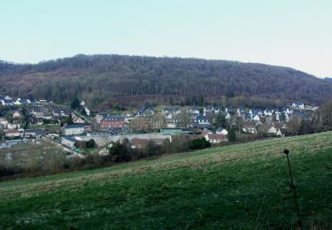
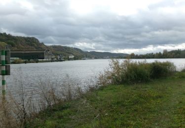
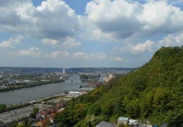
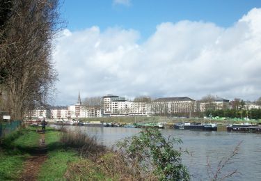
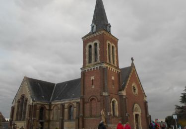
Ruta Senderismo de 6,6 km a descubrir en Normandía, Sena-Marítimo, Amfreville-la-Mi-Voie. Esta ruta ha sido propuesta por randovivi.
Descripción
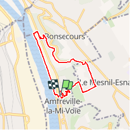
Amfreville la mie voie N°5 entre Bonsecours et Le Mesnil Esnard en passant au bord de Seine
Localización
País:
France
Región :
Normandía
Departamento/provincia :
Sena-Marítimo
Municipio :
Amfreville-la-Mi-Voie
Localidad:
Unknown
Salida:(Dec)
Salida:(UTM)
363815 ; 5474613 (31U) N.
Comentarios
Excursiones cerca
![Excursión Senderismo Darnétal - 076-34-le tour de Darnétal 13km 875-557 - Photo](https://media.geolcdn.com/t/375/260/ext.jpg?maxdim=2&url=https%3A%2F%2Fmedia.geolcdn.com%2Ff%2F8d6b313f-018e-4d0a-9167-39ef9b5d8712.JPG)
![Senderismo Senderismo](https://static1.geolcdn.com/sitytour/trail-icons/101.png)
076-34-le tour de Darnétal 13km 875-557
Senderismo
Medio
(1)
Darnétal,
Normandía,
Sena-Marítimo,
France
![](/images/other/stat-length.png)
9,8 km | 13,1 km-effort
3h 32min
![](https://static1.geolcdn.com/siteimages/upload/files/16400158638029165_repeat_loop_refresh_sync_direction_icon.png)
Sí
![Excursión Senderismo Ruan - 076-102--Bonsecours Darnetal par St Hilaire 13km- - Photo](https://media.geolcdn.com/t/375/260/ext.jpg?maxdim=2&url=https%3A%2F%2Fmedia.geolcdn.com%2Ff%2Fdf16cd3f-22de-4a98-ae5c-66d89f1fbe2e.jpg)
![Senderismo Senderismo](https://static1.geolcdn.com/sitytour/trail-icons/101.png)
076-102--Bonsecours Darnetal par St Hilaire 13km-
Senderismo
Medio
(1)
Ruan,
Normandía,
Sena-Marítimo,
France
![](/images/other/stat-length.png)
13,1 km | 16 km-effort
21min
![](https://static1.geolcdn.com/siteimages/upload/files/16400158638029165_repeat_loop_refresh_sync_direction_icon.png)
Sí
![Excursión Senderismo Saint-Étienne-du-Rouvray - Forêt St. EtienneDu Rouvray P2 (86) - Photo](https://media.geolcdn.com/t/375/260/ext.jpg?maxdim=2&url=https%3A%2F%2Fstatic1.geolcdn.com%2Fsiteimages%2Fupload%2Ffiles%2F1553511878bg_sport_marche.png)
![Senderismo Senderismo](https://static1.geolcdn.com/sitytour/trail-icons/101.png)
Forêt St. EtienneDu Rouvray P2 (86)
Senderismo
Muy fácil
(1)
Saint-Étienne-du-Rouvray,
Normandía,
Sena-Marítimo,
France
![](/images/other/stat-length.png)
9,7 km | 10,7 km-effort
2h 23min
![](https://static1.geolcdn.com/siteimages/upload/files/16400158638029165_repeat_loop_refresh_sync_direction_icon.png)
Sí
![Excursión Senderismo Darnétal - 20240108-Darnetal - Photo](https://media.geolcdn.com/t/375/260/ext.jpg?maxdim=2&url=https%3A%2F%2Fmedia.geolcdn.com%2Ff%2Fd166eaef-b4c4-4c08-9e4b-e31393ca7112.JPG)
![Senderismo Senderismo](https://static1.geolcdn.com/sitytour/trail-icons/101.png)
20240108-Darnetal
Senderismo
Medio
Darnétal,
Normandía,
Sena-Marítimo,
France
![](/images/other/stat-length.png)
10,1 km | 13,4 km-effort
3h 10min
![](https://static1.geolcdn.com/siteimages/upload/files/16400158638029165_repeat_loop_refresh_sync_direction_icon.png)
Sí
![Excursión Senderismo Ruan - 20231109-Rouen - Photo](https://media.geolcdn.com/t/375/260/ext.jpg?maxdim=2&url=https%3A%2F%2Fmedia.geolcdn.com%2Ff%2F7e3ba228-59de-4bee-b079-3f87b9caf2a8.JPG)
![Senderismo Senderismo](https://static1.geolcdn.com/sitytour/trail-icons/101.png)
20231109-Rouen
Senderismo
Fácil
Ruan,
Normandía,
Sena-Marítimo,
France
![](/images/other/stat-length.png)
3,2 km | 3,6 km-effort
57min
![](https://static1.geolcdn.com/siteimages/upload/files/16400158638029165_repeat_loop_refresh_sync_direction_icon.png)
Sí
![Excursión Senderismo Amfreville-la-Mi-Voie - 20230520-Amfreville la Mi Voie - Photo](https://media.geolcdn.com/t/375/260/ext.jpg?maxdim=2&url=https%3A%2F%2Fmedia.geolcdn.com%2Ff%2F8896ed5b-1bc9-47a3-83a3-c79710cc5aa1.JPG)
![Senderismo Senderismo](https://static1.geolcdn.com/sitytour/trail-icons/101.png)
20230520-Amfreville la Mi Voie
Senderismo
Medio
Amfreville-la-Mi-Voie,
Normandía,
Sena-Marítimo,
France
![](/images/other/stat-length.png)
10,8 km | 13,9 km-effort
3h 4min
![](https://static1.geolcdn.com/siteimages/upload/files/16400158638029165_repeat_loop_refresh_sync_direction_icon.png)
Sí
![Excursión Senderismo Ruan - 20230325-Rouen - Photo](https://media.geolcdn.com/t/375/260/ext.jpg?maxdim=2&url=https%3A%2F%2Fmedia.geolcdn.com%2Ff%2F84ff5bf0-f551-4d6e-85dc-6d528861ca2d.JPG)
![Senderismo Senderismo](https://static1.geolcdn.com/sitytour/trail-icons/101.png)
20230325-Rouen
Senderismo
Medio
Ruan,
Normandía,
Sena-Marítimo,
France
![](/images/other/stat-length.png)
11,8 km | 14,6 km-effort
3h 38min
![](https://static1.geolcdn.com/siteimages/upload/files/16400158638029165_repeat_loop_refresh_sync_direction_icon.png)
Sí
![Excursión Senderismo Ruan - 20230311-Les Trois Vallons - Photo](https://media.geolcdn.com/t/375/260/ext.jpg?maxdim=2&url=https%3A%2F%2Fmedia.geolcdn.com%2Ff%2F8f002df3-107f-42a2-9d12-e63da99d3d47.JPG)
![Senderismo Senderismo](https://static1.geolcdn.com/sitytour/trail-icons/101.png)
20230311-Les Trois Vallons
Senderismo
Medio
Ruan,
Normandía,
Sena-Marítimo,
France
![](/images/other/stat-length.png)
10,1 km | 13,4 km-effort
3h 12min
![](https://static1.geolcdn.com/siteimages/upload/files/16400158638029165_repeat_loop_refresh_sync_direction_icon.png)
Sí
![Excursión Senderismo Saint-Aubin-Celloville - 20230225-St Aubin Celloville - Photo](https://media.geolcdn.com/t/375/260/ext.jpg?maxdim=2&url=https%3A%2F%2Fmedia.geolcdn.com%2Ff%2F36834f8f-07d0-45e8-a2c9-4ed3c387ec6f.JPG)
![Senderismo Senderismo](https://static1.geolcdn.com/sitytour/trail-icons/101.png)
20230225-St Aubin Celloville
Senderismo
Medio
Saint-Aubin-Celloville,
Normandía,
Sena-Marítimo,
France
![](/images/other/stat-length.png)
11,8 km | 15 km-effort
3h 30min
![](https://static1.geolcdn.com/siteimages/upload/files/16400158638029165_repeat_loop_refresh_sync_direction_icon.png)
Sí