Excursión Otra actividad Sentein -  - Photo
 LBC83
LBC83

Usuario

© OpenStreetMap contributors
Longitud
Longitud
14,4 km
Altitud máxima
Altitud máxima
1673 m
Desnivel positivo
Desnivel positivo
783 m
Km-Effort
Km-Effort  
26 km
Altitud mínima
Altitud mínima
707 m
Desnivel negativo
Desnivel negativo
1073 m
Boucle
Boucle
No
Fecha de creación :
2014-12-10 00:00:00.0
Última modificación :
2014-12-10 00:00:00.0

(0 Opinión)

Otra actividad
Otra actividad
--
Dificultad : Desconocido

Escanee este código QR para abrir la excursión en la aplicación SityTrail

Aplicación GPS de excursión GRATIS

Logo SityTrail SityTrail

IGN / Institutos geográficos

Descargar SityTrail en App Store Descargar SityTrail en Google Play

Logo SityTrail SityTrail World

El mundo es suyo

Descargar SityTrail en App Store Descargar SityTrail en Google Play Descargar SityTrail en Huawei AppGallery

A propósito

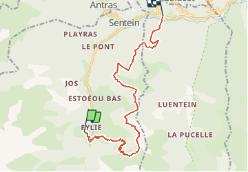
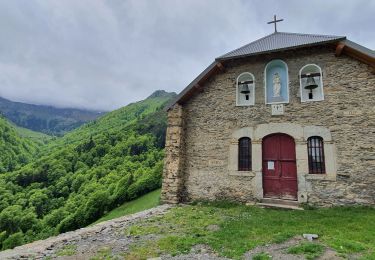
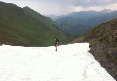
Ruta Otra actividad de 14,4 km a descubrir en Occitania, Ariège, Sentein. Esta ruta ha sido propuesta por LBC83.

Perfil altimétrico

Puntos de interés

Punto de interés Sentein - J1-0:10(966m)0.51km - Photo
LBC83
Punto de interés Sentein - J1-0:20(989m)0.81km - Photo
LBC83
Punto de interés Sentein - J1-0:32(1053m)1.08km - Photo
LBC83
Punto de interés Sentein - J1-0:40(1101m)1.3km - Photo
LBC83
Punto de interés Sentein - J1-0:51(1158m)1.76km - Photo
LBC83
Punto de interés Sentein - J1-1:01(1202m)2.14km - Photo
LBC83
Punto de interés Sentein - J1-1:10(1242m)2.48km - Photo
LBC83
Punto de interés Sentein - J1-1:20(1294m)2.78km - Photo
LBC83
Punto de interés Sentein - J1-1:31(1357m)3.05km - Photo
LBC83
Punto de interés Sentein - J1-1:41(1410m)3.31km - Photo
LBC83
Punto de interés Sentein - J1-1:50(1456m)3.54km - Photo
LBC83
Punto de interés Sentein - J1-2:00(1502m)3.78km - Photo
LBC83
Punto de interés Sentein - J1-2:10(1557m)3.98km - Photo
LBC83
Punto de interés Sentein - J1-2:20(1614m)4.28km - Photo
LBC83
Punto de interés Sentein - J1-2:30(1640m)4.75km - Photo
LBC83
Punto de interés Sentein - J1-2:40(1664m)5.01km - Photo
LBC83
Punto de interés Sentein - J1-2:51(1613m)5.64km - Photo
LBC83
Punto de interés Sentein - J1-3:00(1579m)6km - Photo
LBC83
Punto de interés Sentein - J1-3:10(1554m)6.31km - Photo
LBC83
Punto de interés Sentein - J1-3:23(1502m)6.88km - Photo
LBC83
Punto de interés Sentein - J1-3:30(1502m)7.46km - Photo
LBC83
Punto de interés Sentein - J1-3:41(1512m)7.97km - Photo
LBC83
Punto de interés Sentein - J1-3:50(1477m)8.33km - Photo
LBC83
Punto de interés Sentein - J1-4:01(1400m)9.01km - Photo
LBC83
Punto de interés Sentein - J1-4:10(1401m)9.62km - Photo
LBC83
Punto de interés Sentein - J1-4:50(1258m)11.6km - Photo
LBC83
Punto de interés Bonac-Irazein - J1-5:03(1161m)12.05km - Photo
LBC83
BONAC-IRAZEIN 
Punto de interés Bonac-Irazein - J1-5:11(1145m)12.44km - Photo
LBC83
BONAC-IRAZEIN 
Punto de interés Bonac-Irazein - J1-5:20(1125m)12.96km - Photo
LBC83
BONAC-IRAZEIN 
Punto de interés Bonac-Irazein - J1-5:34(1014m)13.39km - Photo
LBC83
BONAC-IRAZEIN 
Punto de interés Bonac-Irazein - J1-5:40(964m)13.52km - Photo
LBC83
BONAC-IRAZEIN 
Punto de interés Bonac-Irazein - J1-5:54(857m)14.06km - Photo
LBC83
BONAC-IRAZEIN 
Punto de interés Bonac-Irazein - J1-6:03(784m)14.23km - Photo
LBC83
BONAC-IRAZEIN 
Punto de interés Bonac-Irazein - J1-6:10(728m)14.43km - Photo
LBC83
BONAC-IRAZEIN 

Localización

País:
France
Región :
Occitania
Departamento/provincia :
Ariège
Municipio :
Sentein
Localidad:
Unknown
Salida:(Dec)
Salida:(UTM)
331145 ; 4744525 (31T) N.

Excursiones cerca

Excursión Senderismo Sentein - M008-Frechendech à Etang ARAING - Photo
Senderismo
Polo-31

Senderismo

Difícil
(1)
Sentein, Occitania, Ariège, France
24 km | 44 km-effort
10h 0min
Excursión Senderismo Sentein - Araing Crabère - Photo
Senderismo
Gepeto_22

Senderismo

Difícil
(2)
Sentein, Occitania, Ariège, France
32 km | 63 km-effort
9h 49min
No
Excursión Senderismo Bonac-Irazein - tunnels du Biros ou sentier Decauville - Photo
Senderismo
chrisgps

Senderismo

Muy difícil
Bonac-Irazein, Occitania, Ariège, France
17,8 km | 29 km-effort
6h 35min
Excursión Senderismo Bonac-Irazein - Sentier du port d’Orle - col du Tuc - Photo
Senderismo
altaya

Senderismo

Fácil
Bonac-Irazein, Occitania, Ariège, France
13,7 km | 27 km-effort
6h 20min
Excursión Senderismo Sentein - 2022 TRANSPYRÉNÉEN :l’Etand d’Araing -Eylie le haut. - Photo
Senderismo
LEGUE

Senderismo

Difícil
Sentein, Occitania, Ariège, France
9,7 km | 18,1 km-effort
3h 15min
No
Excursión Senderismo Sentein - Cabane d'Illau et chapelle de l'izard  - Photo
Senderismo
chrisgps

Senderismo

Medio
(1)
Sentein, Occitania, Ariège, France
15,2 km | 26 km-effort
6h 46min
Excursión Senderismo Bonac-Irazein - Mail de bulard de Grauillès - Photo
Senderismo
patricklecetre

Senderismo

Muy fácil
(1)
Bonac-Irazein, Occitania, Ariège, France
7,7 km | 24 km-effort
5h 37min
No
Excursión Senderismo Sentein - Le tour du cirque de la plagne - Photo
Senderismo
patricklecetre

Senderismo

Medio
(2)
Sentein, Occitania, Ariège, France
10,3 km | 24 km-effort
4h 7min
Excursión Senderismo Sentein - Pic de Crabere - Photo
Senderismo
istmuso

Senderismo

Muy fácil
(1)
Sentein, Occitania, Ariège, France
32 km | 68 km-effort
Desconocido
No


Cerrar
Mis suscripciones