![](/images/other/stat-length.png)
![Excursión Senderismo Margerie-Chantagret - Margerie Chantagret vers Lavieu - Photo](https://media.geolcdn.com/t/1900/400/ext.pjpeg?maxdim=2&url=https%3A%2F%2Fstatic1.geolcdn.com%2Fsiteimages%2Fupload%2Ffiles%2F1553511878bg_sport_marche.png)
Margerie Chantagret vers Lavieu
gannet1
Usuario
![Longitud](/images/other/stat-length.png)
Longitud
11,7 km
![Altitud máxima](https://static1.geolcdn.com/siteimages/upload/files/1508320355ic_sort_altitude_max_24dp.png)
Altitud máxima
796 m
![Desnivel positivo](https://static1.geolcdn.com/siteimages/upload/files/1508320355ic_sort_den_pos_24dp.png)
Desnivel positivo
340 m
![Km-Effort](/images/other/stat-length.png)
Km-Effort
16,2 km
![Altitud mínima](https://static1.geolcdn.com/siteimages/upload/files/1508320355ic_sort_altitude_min_24dp.png)
Altitud mínima
583 m
![Desnivel negativo](https://static1.geolcdn.com/siteimages/upload/files/1508320355ic_sort_den_neg_24dp.png)
Desnivel negativo
344 m
![Boucle](https://static1.geolcdn.com/siteimages/upload/files/16400158638029165_repeat_loop_refresh_sync_direction_icon.png)
Boucle
Sí
Fecha de creación :
2014-12-18 00:00:00.0
Última modificación :
2014-12-18 00:00:00.0
![Senderismo](https://static1.geolcdn.com/sitytour/trail-icons/101.png)
3h23
Dificultad : Medio
![Escanee este código QR para abrir la excursión en la aplicación SityTrail](https://capi.geolives.com/qq0zvz2zws4bq2lad0pu/sitytour/trails/321987/qr.png?size=200)
Aplicación GPS de excursión GRATIS
A propósito
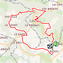
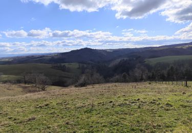
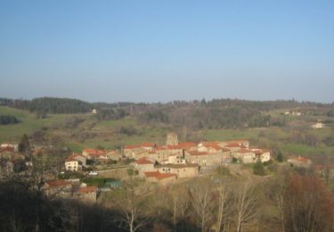
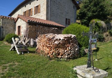
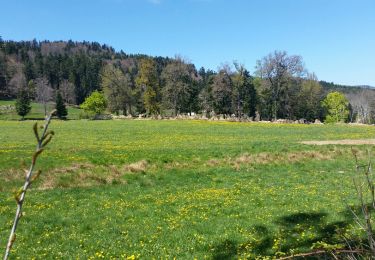
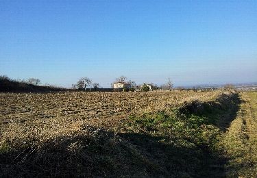
Ruta Senderismo de 11,7 km a descubrir en Auvergne-Rhône-Alpes, Loira, Margerie-Chantagret. Esta ruta ha sido propuesta por gannet1.
Descripción
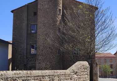
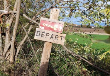
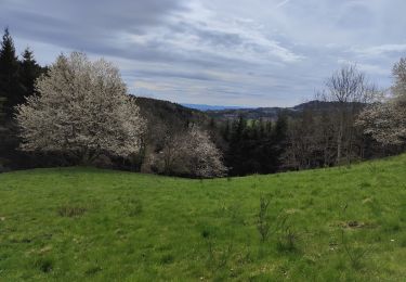
parcours varié : bois, calvaire, chateau, chapelle de Lavieu.
Testé par le groupe de marche de SELM
Localización
País:
France
Región :
Auvergne-Rhône-Alpes
Departamento/provincia :
Loira
Municipio :
Margerie-Chantagret
Localidad:
Unknown
Salida:(Dec)
Salida:(UTM)
581772 ; 5041715 (31T) N.
Comentarios
Excursiones cerca
![Excursión Senderismo Soleymieux - Au dessus de St Jean Soleymieux - Photo](https://media.geolcdn.com/t/375/260/ext.jpg?maxdim=2&url=https%3A%2F%2Fmedia.geolcdn.com%2Ff%2F078ea8f8-b8fb-4f15-aaa5-84b1d4debae2.jpg)
![Senderismo Senderismo](https://static1.geolcdn.com/sitytour/trail-icons/101.png)
Au dessus de St Jean Soleymieux
Senderismo
Medio
Soleymieux,
Auvergne-Rhône-Alpes,
Loira,
France
![](/images/other/stat-length.png)
13,7 km | 20 km-effort
3h 24min
![](https://static1.geolcdn.com/siteimages/upload/files/16400158638029165_repeat_loop_refresh_sync_direction_icon.png)
Sí
![Excursión Senderismo Lavieu - Lavieu D 101 parking - Photo](https://media.geolcdn.com/t/375/260/ext.jpg?maxdim=2&url=https%3A%2F%2Fmedia.geolcdn.com%2Ff%2F801b04a0-2e98-457e-b5cf-20c29f6479d2.jpg)
![Senderismo Senderismo](https://static1.geolcdn.com/sitytour/trail-icons/101.png)
Lavieu D 101 parking
Senderismo
Muy difícil
Lavieu,
Auvergne-Rhône-Alpes,
Loira,
France
![](/images/other/stat-length.png)
14 km | 19,7 km-effort
5h 19min
![](https://static1.geolcdn.com/siteimages/upload/files/16400158638029165_repeat_loop_refresh_sync_direction_icon.png)
Sí
![Excursión Senderismo Chazelles-sur-Lavieu - Randonnée au dessus de Chazelles sur Lavieu - Photo](https://media.geolcdn.com/t/375/260/ext.jpg?maxdim=2&url=https%3A%2F%2Fmedia.geolcdn.com%2Ff%2Fb6692ae6-3e2b-4a04-9819-14d2f06cb08a.jpg)
![Senderismo Senderismo](https://static1.geolcdn.com/sitytour/trail-icons/101.png)
Randonnée au dessus de Chazelles sur Lavieu
Senderismo
Medio
Chazelles-sur-Lavieu,
Auvergne-Rhône-Alpes,
Loira,
France
![](/images/other/stat-length.png)
15,4 km | 22 km-effort
3h 38min
![](https://static1.geolcdn.com/siteimages/upload/files/16400158638029165_repeat_loop_refresh_sync_direction_icon.png)
Sí
![Excursión Senderismo Chenereilles - Randonnée autour de Chenereilles - Photo](https://media.geolcdn.com/t/375/260/ext.jpg?maxdim=2&url=https%3A%2F%2Fmedia.geolcdn.com%2Ff%2F59403294-bac3-4277-8f4f-43e45bfa3417.jpg)
![Senderismo Senderismo](https://static1.geolcdn.com/sitytour/trail-icons/101.png)
Randonnée autour de Chenereilles
Senderismo
Medio
Chenereilles,
Auvergne-Rhône-Alpes,
Loira,
France
![](/images/other/stat-length.png)
11,9 km | 15,8 km-effort
2h 35min
![](https://static1.geolcdn.com/siteimages/upload/files/16400158638029165_repeat_loop_refresh_sync_direction_icon.png)
Sí
![Excursión Bici de montaña Gumières - Gumières - Montagne de Courreau - Gumières - Photo](https://media.geolcdn.com/t/375/260/ext.jpg?maxdim=2&url=https%3A%2F%2Fservices.sitytrail.com%2FGeolivesWS%2FDownloadMedia.ashx%3FTrailID%3D102977%26Media%3D4474_3.jpg)
![Bici de montaña Bici de montaña](https://static1.geolcdn.com/sitytour/trail-icons/202.png)
Gumières - Montagne de Courreau - Gumières
Bici de montaña
Difícil
Gumières,
Auvergne-Rhône-Alpes,
Loira,
France
![](/images/other/stat-length.png)
49 km | 68 km-effort
5h 30min
![](https://static1.geolcdn.com/siteimages/upload/files/16400158638029165_repeat_loop_refresh_sync_direction_icon.png)
No
![Excursión Senderismo Gumières - les montagnes du soir - Photo](https://media.geolcdn.com/t/375/260/ext.jpg?maxdim=2&url=https%3A%2F%2Fmedia.geolcdn.com%2Ff%2Fed5be034-7ba9-4213-a188-3f0eb1939c43.jpg)
![Senderismo Senderismo](https://static1.geolcdn.com/sitytour/trail-icons/101.png)
les montagnes du soir
Senderismo
Fácil
Gumières,
Auvergne-Rhône-Alpes,
Loira,
France
![](/images/other/stat-length.png)
9,5 km | 14,2 km-effort
3h 4min
![](https://static1.geolcdn.com/siteimages/upload/files/16400158638029165_repeat_loop_refresh_sync_direction_icon.png)
Sí
![Excursión Senderismo Chazelles-sur-Lavieu - Chazelle sur Lavieu - Photo](https://media.geolcdn.com/t/375/260/ext.jpg?maxdim=2&url=https%3A%2F%2Fservices.sitytrail.com%2FGeolivesWS%2FDownloadMedia.ashx%3FTrailID%3D738302%26Media%3Dfix__20170423131742.jpg)
![Senderismo Senderismo](https://static1.geolcdn.com/sitytour/trail-icons/101.png)
Chazelle sur Lavieu
Senderismo
Medio
Chazelles-sur-Lavieu,
Auvergne-Rhône-Alpes,
Loira,
France
![](/images/other/stat-length.png)
14,8 km | 21 km-effort
2h 56min
![](https://static1.geolcdn.com/siteimages/upload/files/16400158638029165_repeat_loop_refresh_sync_direction_icon.png)
Sí
![Excursión Otra actividad Lézigneux - 2012-03-01 16h53m07 - Photo](https://media.geolcdn.com/t/375/260/ext.jpg?maxdim=2&url=https%3A%2F%2Fservices.sitytrail.com%2FGeolivesWS%2FDownloadMedia.ashx%3FTrailID%3D114915%26Media%3D20120301164817.jpeg)
![Otra actividad Otra actividad](https://static1.geolcdn.com/sitytour/trail-icons/900.png)
2012-03-01 16h53m07
Otra actividad
Muy fácil
Lézigneux,
Auvergne-Rhône-Alpes,
Loira,
France
![](/images/other/stat-length.png)
7,2 km | 10 km-effort
1h 44min
![](https://static1.geolcdn.com/siteimages/upload/files/16400158638029165_repeat_loop_refresh_sync_direction_icon.png)
Sí
![Excursión Senderismo Saint-Georges-Haute-Ville - St Georges haute ville - Photo](https://media.geolcdn.com/t/375/260/ext.jpg?maxdim=2&url=https%3A%2F%2Fstatic1.geolcdn.com%2Fsiteimages%2Fupload%2Ffiles%2F1553511878bg_sport_marche.png)
![Senderismo Senderismo](https://static1.geolcdn.com/sitytour/trail-icons/101.png)
St Georges haute ville
Senderismo
Difícil
Saint-Georges-Haute-Ville,
Auvergne-Rhône-Alpes,
Loira,
France
![](/images/other/stat-length.png)
12,9 km | 18,1 km-effort
5h 46min
![](https://static1.geolcdn.com/siteimages/upload/files/16400158638029165_repeat_loop_refresh_sync_direction_icon.png)
Sí