Excursión Senderismo Laveissière - Lioran 2023-08-09 Puy de Seycheuse  - Photo

Lioran 2023-08-09 Puy de Seycheuse

 marionneau
marionneau

Usuario

© OpenStreetMap contributors
Longitud
Longitud
14,8 km
Altitud máxima
Altitud máxima
1685 m
Desnivel positivo
Desnivel positivo
730 m
Km-Effort
Km-Effort  
25 km
Altitud mínima
Altitud mínima
1398 m
Desnivel negativo
Desnivel negativo
772 m
Boucle
Boucle
Fecha de creación :
2023-08-09 19:12:11.065
Última modificación :
2023-08-09 19:16:19.233

(0 Opinión)

Senderismo
Senderismo
4h34
Dificultad : Medio

Escanee este código QR para abrir la excursión en la aplicación SityTrail

Aplicación GPS de excursión GRATIS

Logo SityTrail SityTrail

IGN / Institutos geográficos

Descargar SityTrail en App Store Descargar SityTrail en Google Play

Logo SityTrail SityTrail World

El mundo es suyo

Descargar SityTrail en App Store Descargar SityTrail en Google Play Descargar SityTrail en Huawei AppGallery

A propósito

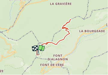
Ruta Senderismo de 14,8 km a descubrir en Auvergne-Rhône-Alpes, Cantal, Laveissière. Esta ruta ha sido propuesta por marionneau.

Descripción

Aller-retour en partant du haut du télésiège de Rombières

Perfil altimétrico

Fotos

Localización

País:
France
Región :
Auvergne-Rhône-Alpes
Departamento/provincia :
Cantal
Municipio :
Laveissière
Localidad:
Unknown
Salida:(UTM)
477765 ; 4993090 (31T) N.

Excursiones cerca

Excursión Senderismo Lavigerie - Le Puy de Peyre Arse depuis la Gravière - Photo
Senderismo
tracegps

Senderismo

Difícil
(2)
Lavigerie, Auvergne-Rhône-Alpes, Cantal, France
11,2 km | 21 km-effort
4h 0min
Excursión Senderismo Laveissière - Le Puy Griou de Super Lioran - Photo
Senderismo
tracegps

Senderismo

Medio
(2)
Laveissière, Auvergne-Rhône-Alpes, Cantal, France
11,9 km | 19,7 km-effort
5h 0min
Excursión Senderismo Laveissière - Le plomb du Cantal - Le Lioran - Photo
Senderismo
tracegps

Senderismo

Medio
(1)
Laveissière, Auvergne-Rhône-Alpes, Cantal, France
14,4 km | 27 km-effort
6h 0min
Excursión Senderismo Laveissière - Les crêtes du Cantal - Le Lioran - Photo
Senderismo
tracegps

Senderismo

Difícil
(4)
Laveissière, Auvergne-Rhône-Alpes, Cantal, France
28 km | 51 km-effort
7h 30min
Excursión Senderismo Mandailles-Saint-Julien - L'Elancèze - Photo
Senderismo
tracegps

Senderismo

Difícil
(1)
Mandailles-Saint-Julien, Auvergne-Rhône-Alpes, Cantal, France
12,8 km | 24 km-effort
5h 0min
Excursión Senderismo Laveissière - le Peyre Arse - Le Lioran - Photo
Senderismo
tracegps

Senderismo

Difícil
(1)
Laveissière, Auvergne-Rhône-Alpes, Cantal, France
11,2 km | 19,4 km-effort
4h 0min
No
Excursión Senderismo Laveissière - Lioran 2023-08-18 Col de Rombière Col du Pertus A/R - Photo
Senderismo
marionneau

Senderismo

Fácil
(1)
Laveissière, Auvergne-Rhône-Alpes, Cantal, France
12,5 km | 18,8 km-effort
4h 14min
Excursión Senderismo Laveissière - Lioran 2023-08-11 Col du Pertus - Photo
Senderismo
marionneau

Senderismo

Medio
(1)
Laveissière, Auvergne-Rhône-Alpes, Cantal, France
17,3 km | 25 km-effort
2h 57min
Excursión Senderismo Laveissière - Lioran 2023-08-09 Puy de Seycheuse - Photo
Senderismo
marionneau

Senderismo

Muy difícil
(1)
Laveissière, Auvergne-Rhône-Alpes, Cantal, France
13,9 km | 23 km-effort
5h 20min


Cerrar
Mis suscripciones