![](/images/other/stat-length.png)
![Excursión Senderismo Correns - correns le valon sourn - Photo](https://media.geolcdn.com/t/1900/400/ext.pjpeg?maxdim=2&url=https%3A%2F%2Fstatic1.geolcdn.com%2Fsiteimages%2Fupload%2Ffiles%2F1553511878bg_sport_marche.png)
correns le valon sourn
gastienne
Usuario
![Longitud](/images/other/stat-length.png)
Longitud
13,1 km
![Altitud máxima](https://static1.geolcdn.com/siteimages/upload/files/1508320355ic_sort_altitude_max_24dp.png)
Altitud máxima
293 m
![Desnivel positivo](https://static1.geolcdn.com/siteimages/upload/files/1508320355ic_sort_den_pos_24dp.png)
Desnivel positivo
249 m
![Km-Effort](/images/other/stat-length.png)
Km-Effort
16,4 km
![Altitud mínima](https://static1.geolcdn.com/siteimages/upload/files/1508320355ic_sort_altitude_min_24dp.png)
Altitud mínima
164 m
![Desnivel negativo](https://static1.geolcdn.com/siteimages/upload/files/1508320355ic_sort_den_neg_24dp.png)
Desnivel negativo
252 m
![Boucle](https://static1.geolcdn.com/siteimages/upload/files/16400158638029165_repeat_loop_refresh_sync_direction_icon.png)
Boucle
Sí
Fecha de creación :
2024-05-06 10:00:17.333
Última modificación :
2024-05-06 10:03:07.305
![Senderismo](https://static1.geolcdn.com/sitytour/trail-icons/101.png)
3h43
Dificultad : Difícil
![Escanee este código QR para abrir la excursión en la aplicación SityTrail](https://capi.geolives.com/qq0zvz2zws4bq2lad0pu/sitytour/trails/4042817/qr.png?size=200)
Aplicación GPS de excursión GRATIS
A propósito
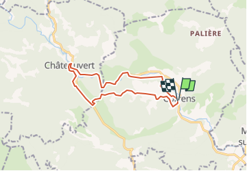
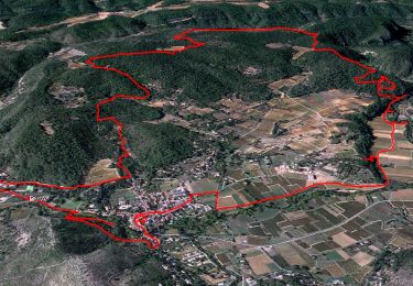
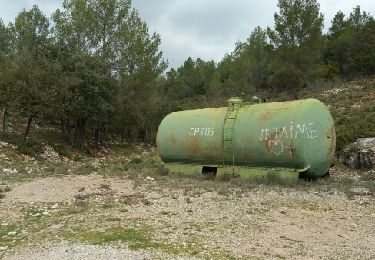
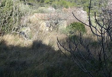
Ruta Senderismo de 13,1 km a descubrir en Provenza-Alpes-Costa Azul, Var, Correns. Esta ruta ha sido propuesta por gastienne.
Descripción
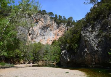
depart correns direction le gué de l'argens qui permet de franchir l'argens pour rejoindre le valon sourn ( sauf en cas de grosses pluies) traverser chateau vert et revenir à correns
Localización
País:
France
Región :
Provenza-Alpes-Costa Azul
Departamento/provincia :
Var
Municipio :
Correns
Localidad:
Unknown
Salida:(Dec)
Salida:(UTM)
263914 ; 4819043 (32T) N.
Comentarios
Excursiones cerca
![Excursión Senderismo Correns - Le patrimoine - l'Argens - Le village - Photo](https://media.geolcdn.com/t/375/260/ext.jpg?maxdim=2&url=https%3A%2F%2Fmedia.geolcdn.com%2Ff%2F405a713c-9f67-402a-9b2f-998d4bced48b.jpg)
![Senderismo Senderismo](https://static1.geolcdn.com/sitytour/trail-icons/101.png)
Le patrimoine - l'Argens - Le village
Senderismo
Fácil
(1)
Correns,
Provenza-Alpes-Costa Azul,
Var,
France
![](/images/other/stat-length.png)
14,2 km | 18,1 km-effort
6h 0min
![](https://static1.geolcdn.com/siteimages/upload/files/16400158638029165_repeat_loop_refresh_sync_direction_icon.png)
Sí
![Excursión Senderismo Correns - Correns - Val Obscur - Rive de l'Argens - Grotte aux Fées - Châteauvert - Vallon Sourn - Photo](https://media.geolcdn.com/t/375/260/ext.jpg?maxdim=2&url=https%3A%2F%2Fmedia.geolcdn.com%2Ff%2F147037ca-3255-40a4-bbd2-cb1cf8ea8190.JPG)
![Senderismo Senderismo](https://static1.geolcdn.com/sitytour/trail-icons/101.png)
Correns - Val Obscur - Rive de l'Argens - Grotte aux Fées - Châteauvert - Val...
Senderismo
Medio
Correns,
Provenza-Alpes-Costa Azul,
Var,
France
![](/images/other/stat-length.png)
21 km | 27 km-effort
4h 57min
![](https://static1.geolcdn.com/siteimages/upload/files/16400158638029165_repeat_loop_refresh_sync_direction_icon.png)
Sí
![Excursión Senderismo Correns - Correns-18-03-22 - Photo](https://media.geolcdn.com/t/375/260/ext.jpg?maxdim=2&url=https%3A%2F%2Fmedia.geolcdn.com%2Ff%2F09a33764-10f5-4925-96d0-198bf65221a1.jpg)
![Senderismo Senderismo](https://static1.geolcdn.com/sitytour/trail-icons/101.png)
Correns-18-03-22
Senderismo
Medio
Correns,
Provenza-Alpes-Costa Azul,
Var,
France
![](/images/other/stat-length.png)
11,9 km | 14,9 km-effort
4h 10min
![](https://static1.geolcdn.com/siteimages/upload/files/16400158638029165_repeat_loop_refresh_sync_direction_icon.png)
Sí
![Excursión Bici de montaña Correns - Correns à faire - Photo](https://media.geolcdn.com/t/375/260/ext.jpg?maxdim=2&url=https%3A%2F%2Fmedia.geolcdn.com%2Ff%2F6347d8bc-2d08-4062-9163-62c8d555de14.jpg)
![Bici de montaña Bici de montaña](https://static1.geolcdn.com/sitytour/trail-icons/202.png)
Correns à faire
Bici de montaña
Medio
Correns,
Provenza-Alpes-Costa Azul,
Var,
France
![](/images/other/stat-length.png)
25 km | 32 km-effort
2h 55min
![](https://static1.geolcdn.com/siteimages/upload/files/16400158638029165_repeat_loop_refresh_sync_direction_icon.png)
Sí
![Excursión Bici de montaña Correns - Correns fait - Photo](https://media.geolcdn.com/t/375/260/ext.jpg?maxdim=2&url=https%3A%2F%2Fmedia.geolcdn.com%2Ff%2Ffe3c3b00-1fdc-4b15-9762-f76acb0abcaa.jpg)
![Bici de montaña Bici de montaña](https://static1.geolcdn.com/sitytour/trail-icons/202.png)
Correns fait
Bici de montaña
Medio
Correns,
Provenza-Alpes-Costa Azul,
Var,
France
![](/images/other/stat-length.png)
26 km | 34 km-effort
2h 55min
![](https://static1.geolcdn.com/siteimages/upload/files/16400158638029165_repeat_loop_refresh_sync_direction_icon.png)
Sí
![Excursión Senderismo Correns - Correns - Le val Sourn - Photo](https://media.geolcdn.com/t/375/260/ext.jpg?maxdim=2&url=https%3A%2F%2Fstatic1.geolcdn.com%2Fsiteimages%2Fupload%2Ffiles%2F1553511878bg_sport_marche.png)
![Senderismo Senderismo](https://static1.geolcdn.com/sitytour/trail-icons/101.png)
Correns - Le val Sourn
Senderismo
Medio
(1)
Correns,
Provenza-Alpes-Costa Azul,
Var,
France
![](/images/other/stat-length.png)
11,2 km | 15,2 km-effort
3h 16min
![](https://static1.geolcdn.com/siteimages/upload/files/16400158638029165_repeat_loop_refresh_sync_direction_icon.png)
Sí
![Excursión Senderismo Correns - Correns reco Bernard 20.03.17 - Photo](https://media.geolcdn.com/t/375/260/ext.jpg?maxdim=2&url=https%3A%2F%2Fservices.sitytrail.com%2FGeolivesWS%2FDownloadMedia.ashx%3FTrailID%3D717809%26Media%3Dfix__20170320110319.jpg)
![Senderismo Senderismo](https://static1.geolcdn.com/sitytour/trail-icons/101.png)
Correns reco Bernard 20.03.17
Senderismo
Medio
Correns,
Provenza-Alpes-Costa Azul,
Var,
France
![](/images/other/stat-length.png)
16,5 km | 21 km-effort
4h 34min
![](https://static1.geolcdn.com/siteimages/upload/files/16400158638029165_repeat_loop_refresh_sync_direction_icon.png)
Sí
![Excursión Senderismo Le Val - Montée du Cuit - Photo](https://media.geolcdn.com/t/375/260/ext.jpg?maxdim=2&url=https%3A%2F%2Fstatic1.geolcdn.com%2Fsiteimages%2Fupload%2Ffiles%2F1553511878bg_sport_marche.png)
![Senderismo Senderismo](https://static1.geolcdn.com/sitytour/trail-icons/101.png)
Montée du Cuit
Senderismo
Medio
(1)
Le Val,
Provenza-Alpes-Costa Azul,
Var,
France
![](/images/other/stat-length.png)
7,3 km | 11 km-effort
1h 50min
![](https://static1.geolcdn.com/siteimages/upload/files/16400158638029165_repeat_loop_refresh_sync_direction_icon.png)
Sí
![Excursión Senderismo Montfort-sur-Argens - montfort correns - Photo](https://media.geolcdn.com/t/375/260/ext.jpg?maxdim=2&url=https%3A%2F%2Fservices.sitytrail.com%2FGeolivesWS%2FDownloadMedia.ashx%3FTrailID%3D254784%26Media%3Dfix__20140306153812.jpg)
![Senderismo Senderismo](https://static1.geolcdn.com/sitytour/trail-icons/101.png)
montfort correns
Senderismo
Muy fácil
(1)
Montfort-sur-Argens,
Provenza-Alpes-Costa Azul,
Var,
France
![](/images/other/stat-length.png)
15,6 km | 19,6 km-effort
4h 52min
![](https://static1.geolcdn.com/siteimages/upload/files/16400158638029165_repeat_loop_refresh_sync_direction_icon.png)
Sí