


3,3 km | 4,6 km-effort
Cadix : découvrez les meilleures randonnées : 10 a pied et 21 marche. Tous ces circuits, parcours, itinéraires et activités en plein air sont disponibles dans nos applications SityTrail pour smartphones et tablettes.
A pied


• Randonnée créée par Junta de Andalucía. Symbole: -
A pied
• Randonnée créée par Junta de Andalucía. Symbole: -
A pied
• Randonnée créée par Junta de Andalucía. Symbole: -
A pied
• Randonnée créée par Junta de Andalucía. Symbole: -
A pied
• Randonnée créée par Junta de Andalucía. Symbole: -
A pied
• Randonnée créée par Junta de Andalucía. Symbole: -
A pied
• Randonnée créée par Junta de Andalucía. Symbole: -
A pied
• Randonnée créée par Junta de Andalucía. Symbole: -

Marche
• More information on GPStracks.nl : http://www.gpstracks.nl
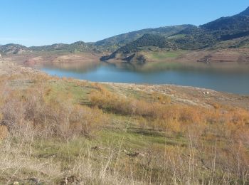
Marche
• Randonnée à partir du village vers le lac.
Marche
• Parcours dans la montagne d'Olvera ,sur de larges chemins de culture d'oliviers . Vue sur le village. Attention plusi...
A pied
• Randonnée créée par Junta de Andalucía. Symbole: -
Marche
• Surplombant le détroit de Gibraltar à travers champs et le long des falaises

A pied
• Randonnée créée par Junta de Andalucía. Symbole: -
Marche
• se me ha olvidado detenerlo cuando pillamos el coche! son 1,5km, 1hora con niños pequeños.
Marche
•
Marche
• More information on GPStracks.nl : http://www.gpstracks.nl
Marche
Marche
Marche
20 randonnées affichées sur 31
Application GPS de randonnée GRATUITE
 SityTrail
IGN / Instituts géographiques
SityTrail World
Le monde est à vous